El Niño and Atlantic Niña are converging. What it means for weather

Daftar Isi
El Niño and Atlantic Niña are converging: Unprecedented Ocean Signals Converge as Hurricane Season Approaches Cybersecarmor.com – The world's oceans are
Unprecedented Ocean Signals Converge as Hurricane Season Approaches
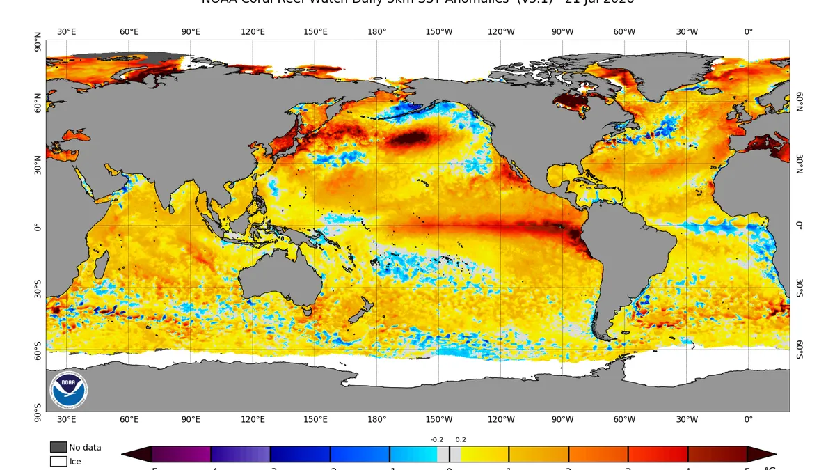
Cybersecarmor.com – The world’s oceans are currently broadcasting two distinct and unusual climate signals simultaneously. According to meteorological experts at Severe Weather Europe, a rare Atlantic Niña phenomenon has materialized in the tropical Atlantic region, while a powerful Super El Niño continues strengthening across the equatorial Pacific. These opposing oceanic patterns, separated by vast distances, are now converging in ways that could significantly impact global weather systems.
Opposing Forces, Unified Impact
On the surface, these two phenomena appear contradictory. The Atlantic Niña brings cooler-than-normal sea surface temperatures to the tropical Atlantic, whereas the Super El Niño generates warmer-than-average conditions in the Pacific. However, both patterns exert similar atmospheric influences. They alter air movement patterns, affecting where air rises and descends, modifying storm development zones, and reshaping large-scale weather configurations.
“A rare Atlantic Niña has appeared in the tropics, just as a powerful Super El Niño continues to build in the Pacific,” the Severe Weather Europe analysis states. “These two ocean anomalies may look opposite on the map, but their atmospheric impact is pushing in the same direction, creating an atmospheric shield for the United States hurricane season.”
Weather forecasters are closely monitoring this unusual combination because the dual patterns may reinforce conditions that suppress Atlantic tropical activity during the critical hurricane season buildup period.
Understanding the Atlantic Niña Phenomenon
While most people recognize El Niño and La Niña as Pacific Ocean phenomena within the El Niño-Southern Oscillation framework, a comparable pattern exists in the tropical Atlantic. According to the National Oceanic and Atmospheric Administration, an Atlantic Niña develops when sea surface temperatures in the central and eastern tropical Atlantic drop below average levels.
These cooler waters influence the atmosphere through reduced evaporation rates, which limits the heat and moisture available to power thunderstorm development. During hurricane season, this matters considerably since the tropical Atlantic serves as a primary nursery for numerous tropical storms.
A cooler Atlantic typically correlates with decreased atmospheric instability, increased sinking air masses, diminished thunderstorm activity, and an overall less favorable environment for tropical system formation. The Atlantic Niña occurs less frequently than its Pacific counterpart, partly because the tropical Atlantic represents a smaller and more variable ocean basin, according to the Climate Prediction Center.
Unusual Timing Creates Historical Significance
The current pattern stands out due to its timing. The tropical Atlantic normally ranks among the warmest global regions during summer months, having accumulated heat from months of solar warming. These warm waters typically provide essential fuel for thunderstorms and tropical systems throughout hurricane season.
A substantial cooling trend in the tropical Atlantic during this period remains uncommon because it contradicts the expected seasonal warming trajectory. If this cooling persists and the anomaly stays below the classification threshold for Atlantic Niña events, it would rank among only a handful of similar occurrences in the historical record.
El Niño’s Role in Suppressing Storm Activity
El Niño occurs when a vast area of the Pacific Ocean near the equator becomes warmer than normal, according to NOAA. This additional heat extends beyond the ocean surface, altering global air circulation patterns. Since the ocean and atmosphere remain interconnected, temperature changes in one region can influence weather systems thousands of miles away.
During hurricane season, El Niño frequently works against Atlantic storm development. Wind shear represents one of the primary mechanisms, occurring when atmospheric winds at different altitudes blow in varying directions or at different speeds. Excessive wind shear can disrupt the thunderstorms that tropical systems require for growth, making storm organization and intensification more difficult.
Additionally, El Niño can generate conditions where air sinks over portions of the Atlantic. While rising air promotes thunderstorm development, sinking air functions like an atmospheric lid, inhibiting storm formation. Together, these effects can reduce the likelihood of an active Atlantic hurricane season.
However, El Niño does not prevent hurricanes entirely. Some of the most devastating hurricanes in recorded history have occurred during El Niño years, demonstrating that while these patterns influence probability, they do not guarantee outcomes.
Related SEO Topics
- Home
- Artikel terkait El Niño and Atlantic Niña are converging
- Fetterman calls out Trump over 2020 election claims: ‘You’re the president’
- Nolan Wells’ family releases independent autopsy results
- Cardi B gets real about ambition, pet peeves, mom guilt and vices | Exclusive
- William Shatner reveals he and daughter Melanie fought Stage 4 cancer at same time
Frequently Asked Questions
What is El Niño and Atlantic Niña are converging?
El Niño and Atlantic Niña are converging is the main topic covered in this article, with practical context to help readers understand the subject clearly.
Why does El Niño and Atlantic Niña are converging matter?
El Niño and Atlantic Niña are converging matters because it helps readers compare options, avoid common mistakes, and make a more informed decision.
How should readers use this El Niño and Atlantic Niña are converging guide?
Use the key points, examples, and related links in this page as a starting point, then review the latest details before making a final decision.