An unprecedented El Niño sends scientists scrambling for answers

Daftar Isi
Scientists mobilize as an unusually powerful El Niño takes shape
Cybersecarmor.com – An El Niño developing across the equatorial Pacific may become one of the strongest observed in more than seven decades, giving climate researchers a rare chance to examine a major event as it unfolds.
In a September 10 outlook, the National Oceanic and Atmospheric Administration put the chance at 75% that the developing pattern will surpass every El Niño recorded since 1950. The prospect has prompted researchers to deploy new tools and closely track an ocean region already experiencing record-high sea-surface temperatures for this point in the year.
“It’s an opportunity to learn more about what El Niño is going to look like in a warmer climate,” said Emily Becker, a research associate at the University of Miami’s Rosenstiel School of Marine, Atmospheric, and Earth Science.
El Niño is a recurring climate pattern involving unusually warm water in the central and eastern tropical Pacific. Its influence can extend far beyond the ocean, shifting atmospheric circulation and affecting rainfall, storm activity, agriculture, energy demand, fisheries and water supplies in many parts of the world. While forecasting has improved substantially, scientists still want a clearer understanding of the smaller, faster changes that can shape how each event evolves.
Autonomous vessels head toward the equatorial Pacific
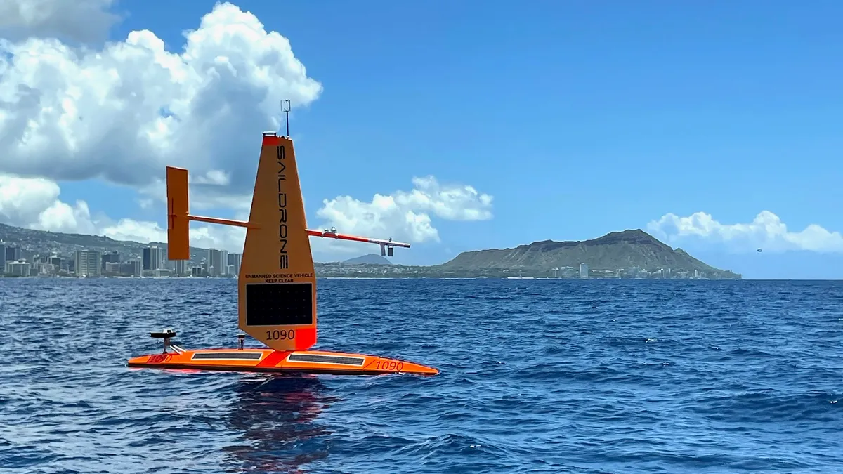
Four autonomous Saildrone Explorers recently departed waters off Honolulu for the equatorial Pacific, where they are expected to operate for five months. The mission briefly had to change course when Hurricane Lowell approached the Hawaiian Islands, requiring the vessels to be directed away from dangerous conditions before resuming their voyage.
The 23-foot Saildrone Explorers are uncrewed surface vehicles sometimes described as robotic surfboards. Powered by wind and solar energy, they can be sent toward areas where researchers need more observations. Similar models have previously supported research in the Atlantic hurricane basin.
Each vessel carries 15 meteorological and oceanographic instruments, said Cristina Castillo, Saildrone’s senior program manager of ocean science. Those sensors continuously monitor variables including temperature, salinity, carbon dioxide and ocean currents.
The ability to position instruments in a developing climate event is particularly valuable in a remote part of the ocean where direct measurements can be limited. Conditions occurring thousands of miles from land can help steer global weather patterns and influence the likelihood of intense storms, flooding and disruptions to fisheries, Castillo said.
“The wind-propelled and solar-powered drones can be moved to locations where scientists want to collect more data,” Castillo said.
The project links researchers at NOAA’s Pacific Marine Environmental Laboratory and the University of Washington through the Cooperative Institute for Climate, Ocean & Ecosystem Studies. Dongxiao Zhang, NOAA’s lead investigator, said the vehicles can focus observations where information is most urgently needed during rapidly changing air-sea events.
“Open a new era of ocean observation by targeting areas where data are most needed to improve our understanding and forecasts of high-impact, rapidly developing air-sea processes like this El Niño, that will have profound effects around the world,” Zhang said.
From surprise events to continuous observation
Michael McPhaden, now a researcher at the University of Washington, has studied El Niño for almost 50 years. He retired as a senior NOAA scientist in June, but the scale of the developing event has kept him engaged in the field.
McPhaden’s early career was shaped by the major El Niño of 1982. At that time, ocean monitoring and prediction systems were far less capable than they are now.
“We had no observing system, we didn’t see it coming,” McPhaden said. “We had no forecast models. We didn’t actually realize it was happening until it was nearly at its peak.”
The event arrived as the international scientific community was preparing a decade-long initiative focused on El Niño. McPhaden characterized the surprise as a “shock and embarrassment.” Beginning in 1984, that effort built an extensive network of satellite observations and ocean platforms intended to monitor the Pacific more effectively.
That observing network has since been redesigned, and it is now supplying continuous data as the current El Niño develops. Meghan Cronin, a research oceanographer who leads the Ocean Climate Stations group at NOAA’s Pacific Marine Environmental Laboratory, said the incoming measurements offer a view that would otherwise be impossible to obtain.
“A lot more information than we could see in any other way,” Cronin said.
The expanded observations are expected to help researchers examine the interaction between ocean heat, winds, currents and the atmosphere. Such measurements can improve the detail of forecasts, not simply identify whether El Niño or its cooler counterpart, La Niña, is likely to occur.
Searching for the spark
Decades of research have strengthened scientists’ understanding of broad ocean and atmospheric processes. That progress has made it easier to anticipate El Niño and La Niña and has also improved tropical storm and hurricane outlooks worldwide.
The next challenge is to better resolve the smaller-scale disturbances that may help trigger or intensify an El Niño. McPhaden compares the pattern to a bonfire: accumulated ocean warmth acts like dry fuel, while short-lived weather disruptions may provide the ignition. That spark does not always begin in the same location, making it difficult to capture with conventional observations alone.
The Saildrone mission and the existing Pacific observing system may help fill in those missing details. Better forecasts can give communities, utilities, farmers, water managers and emergency planners more time to prepare for weather shifts connected to the Pacific.
“We’ll really hopefully make some big progress on being able to improve our forecast of these events that have such a big impact on water resources, energy resources, agriculture, and our lives,” Cronin said.
For scientists, the developing El Niño is both a warning sign and an uncommon research opportunity. The measurements gathered over the coming months could help clarify how a warming climate influences these powerful Pacific events and how their global consequences can be forecast with greater confidence.
Related Reading
Frequently Asked Questions
What is An unprecedented El Niño sends scientists?
An unprecedented El Niño sends scientists is the main topic of this guide. The article explains the context, practical details, and next steps readers should understand.
Why does An unprecedented El Niño sends scientists matter?
An unprecedented El Niño sends scientists matters because readers are looking for a useful answer, not just a short summary. Good content should match search intent and help them decide what to do next.