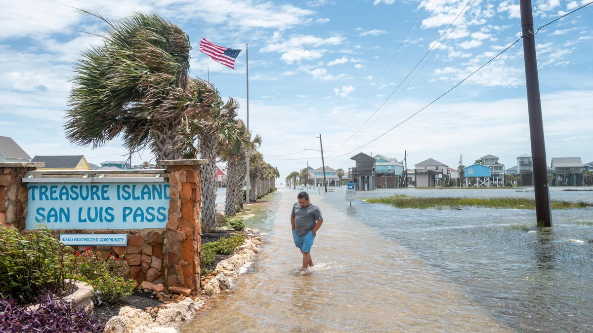
South continues to deal with flooding, rains from Arthur’s remnants
South continues to deal with flooding – As of Friday, June 19, 2026, parts of Texas, Louisiana, Mississippi, Alabama, Georgia, and Florida remain under active thunderstorm and flood alerts due to the lingering influence of the first named tropical storm of the Atlantic hurricane season, Arthur. Though Arthur itself has weakened and no longer qualifies as a tropical storm, its remnants are continuing to deliver substantial rainfall to the Southeast, prompting officials to issue warnings about the potential for flash flooding in coastal regions. The National Weather Service (NWS) has been closely monitoring the situation, emphasizing that the ongoing precipitation could pose significant risks to communities already struggling with saturated soil and rising water levels.
The remnants of Arthur, now a disorganized system of moisture and showers, are slowly moving eastward, affecting the lower Mississippi Valley and the Gulf Coast. Forecasters have indicated that while the intensity of the rain has decreased compared to earlier in the week, the cumulative effect of repeated downpours could still lead to widespread flooding. Areas near the coast, in particular, are under heightened risk as the stalled weather front continues to feed moisture into the region. This slow movement has allowed for prolonged rainfall, which combined with the region’s already soaked ground, could turn minor streams into raging rivers and cause disruptions to infrastructure.
Weather patterns and flood risks
Experts at the NWS have warned that the current weather system could generate flash floods with “significant and potentially life-threatening” consequences for parts of the Gulf Coast. The conditions are expected to worsen in the coming days as the remnants of Arthur interact with warm ocean currents and unstable atmospheric conditions. In some areas, rainfall rates could reach up to 3 inches per hour, overwhelming drainage systems and creating hazardous conditions for drivers and pedestrians. The warning highlights the importance of preparedness, especially in regions where residents have already experienced weeks of heavy rain.
While the storm’s remnants may not bring the same level of intensity as earlier in the week, the prolonged nature of the precipitation is a key concern. Meteorologists note that the system is expected to remain in the area for several days, with the potential for scattered thunderstorms and downpours. This timeline means that communities must stay alert even as the immediate threat of a full-blown tropical storm diminishes. The NWS has also urged residents to monitor local forecasts and remain vigilant for changes in weather patterns that could intensify the situation.
Watching the oceans: Feds cancel plan to rip out ocean monitoring system after backlash
Amid the ongoing weather crisis, a new development has emerged that could impact future monitoring efforts. Federal officials had initially proposed dismantling parts of the National Oceanic and Atmospheric Administration’s (NOAA) ocean monitoring system to cut costs, but the plan has been put on hold following widespread public and scientific criticism. NOAA’s system plays a critical role in tracking ocean temperatures, wave heights, and storm development, providing essential data for accurate forecasts and disaster response.
Officials cited concerns about the system’s redundancy and the potential for increased budget allocations to other programs. However, environmental advocates and weather experts argued that removing key components of the system could compromise early warning capabilities, especially during hurricane season. The backlash has led to a reevaluation of the proposal, with some lawmakers calling for a delay until the system’s efficiency can be assessed through alternative methods. This decision underscores the growing recognition of the importance of continuous ocean monitoring in predicting and mitigating the impacts of severe weather events like Arthur’s remnants.
Community resilience and safety tips
Local authorities are reminding residents that staying informed is one of the most effective ways to protect against storm-related dangers. “Your community’s emergency management officials are your first line of defense,” said National Hurricane Center director Michael Brennan in a recent interview with USA TODAY. “They know the local geography, the risks, and how to respond quickly. Trust them, and follow their guidance closely.”
“Know who your local emergency management officials are in your county or city. They’re the people in your community that are going to tell you what you need to stay safe. Local government officials. … Your local National Weather Service office. Hurricanes.gov, the Hurricane Center,” Brennan added.
Brennan emphasized that the NWS’s role in tracking storms and providing real-time updates is vital, especially for areas prone to flooding. He noted that the center’s data-driven approach helps communities prepare for extreme weather, from issuing timely alerts to coordinating rescue operations. In the case of Arthur’s remnants, the NWS has been working closely with local governments to ensure that evacuation plans are in place and that emergency shelters are stocked with supplies.
Residents in the Southeast are being advised to take proactive measures, such as securing property, keeping emergency kits ready, and avoiding low-lying areas during heavy rain. “Even if the storm seems to be weakening, the water can still rise rapidly,” said a spokesperson for the Louisiana Office of Emergency Management. “We urge everyone to stay indoors, monitor local news, and avoid driving through flooded streets.”
The situation also highlights the broader challenges of climate change and its effect on weather patterns. With rising sea levels and more frequent extreme precipitation events, the Southeast is increasingly vulnerable to flooding, even from systems that are no longer classified as tropical storms. Scientists warn that the region’s infrastructure may need to be upgraded to handle the growing frequency of such weather events, which could have long-term economic and environmental consequences.
As the remnants of Arthur continue their journey eastward, the focus remains on minimizing damage and ensuring public safety. While the immediate threat of a full-blown storm has passed, the impact of the rain and flooding will be felt for days to come. This serves as a reminder of the delicate balance between nature’s forces and human preparedness, with communities now relying on both advanced technology and local expertise to navigate the challenges of the hurricane season.
Authorities are also working to coordinate relief efforts, with emergency teams deployed to areas most at risk of flash flooding. The collaboration between federal, state, and local agencies is crucial in responding to the crisis, as it allows for a more tailored approach to disaster management. In addition to physical preparations, officials are encouraging residents to stay connected through social media and local news channels for updates on the weather and any changes to the flood warning system.
With the potential for scattered downpours and flash flooding persisting, the Southeast is in for a prolonged period of wet weather. While the remnants of Arthur may not be as powerful as they once were, their lingering effects could still disrupt daily life and strain resources. The NWS and local governments are under pressure to maintain their efforts and ensure that all residents have access to the information they need to stay safe. As the weather continues to evolve, the emphasis on preparedness and community resilience remains stronger than ever.