Midwest, East Coast could see damaging winds, flash flooding this week

Daftar Isi
Severe Weather System Targets Northern Corridor and Eastern Seaboard
Storms to Bring Damaging Winds and Flash Flooding This Week
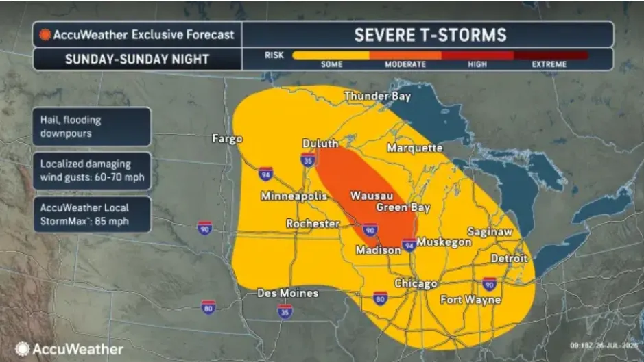
Cybersecarmor.com – A powerful weather system is set to unleash a barrage of thunderstorms across the nation’s northern regions beginning Sunday evening. According to meteorologists, these storms will deliver hail, strong winds, and heavy rainfall that could disrupt Monday evening commutes with flash flooding and gusty downpours.
The Great Lakes area and Ohio Valley stand to experience the most significant impacts as the storm system moves through. These regions will see the storms pass along the upper boundary of an extensive heat dome currently covering the Plains states. The combination of abundant heat and moisture is expected to fuel intense thunderstorm development across eastern Minnesota and northern Wisconsin.
Brandon Buckingham, a meteorologist with Accuweather, noted that the system should intensify into a widespread storm complex by Sunday evening. The advancing storms will carry heavy precipitation and produce “wide swaths of damaging wind gusts” reaching speeds of up to 85 miles per hour as they push southeastward into the Great Lakes region.
Day-to-day thunderstorm activity can sometimes rely on where previous rounds of thunderstorms develop, which makes pinning down the exact location of the highest risk for severe weather difficult until just a matter of hours before storms form,
Buckingham explained.
Already, the same storm system demonstrated its power on Saturday night when it struck Sioux Falls, South Dakota. The city experienced sustained winds of 80 miles per hour with gusts exceeding 90 miles per hour in the southern outskirts. The intense winds knocked out power for thousands of residents in the affected area.
As the weather system continues its eastward trajectory, the National Weather Service has warned that fallen tree limbs and additional power outages remain likely. Lightning strikes and heavy rainfall are anticipated throughout Monday afternoon and evening as the storm progresses through the region.
Travel Disruptions Expected Along Major Corridors
The severe weather pattern will eventually extend into the Northeast and mid-Atlantic regions, creating particularly challenging travel conditions. The Interstate 95 corridor stretching from New York City to Raleigh, North Carolina, faces the brunt of the impacts. Travelers along this route should expect damaging wind gusts, hail, and persistent downpours throughout the affected period.
Prolonged, heavy rainfall along the northern edge of the storm system is forecast to continue through Tuesday evening. This extended precipitation is raising concerns about flash flooding potential across a broad area from Buffalo to Boston. Residents and commuters in these cities should monitor local conditions closely.
By Wednesday, the weather system could bring severe weather threats to portions of New England. Urban areas and locations with inadequate drainage systems face particular risk for flash flooding as water accumulates in streets and low-lying areas.
Heat Wave Continues in Southern Regions
While northern areas deal with storms and flooding, the central and southern United States is experiencing hazardous heat conditions according to the National Weather Service. Afternoon temperatures on Sunday and Monday are expected to reach the upper 90s and lower 100s Fahrenheit across multiple states.
Heat indices could climb to between 105 and 115 degrees throughout parts of the Rocky Mountains, the Plains states, the Mississippi Valley, and sections of the South. The combination of high temperatures and humidity creates dangerous conditions for outdoor activities and those without adequate cooling resources.
Meteorologists are advising residents across both the storm-affected northern regions and the hot southern areas to take appropriate precautions. Those in the path of the storms should secure outdoor items and prepare for potential power disruptions, while southern residents should stay hydrated and limit exposure during peak heat hours.
The weather system’s progression will be closely monitored through the week, with updates expected as the storm’s exact path and intensity become clearer. Communities from the Great Lakes to New England should remain alert for changing conditions as the system moves through their regions over the coming days.
Related Reading
Frequently Asked Questions
What is Midwest East Coast could see damaging?
Midwest East Coast could see damaging is the main topic of this guide. The article explains the context, practical details, and next steps readers should understand.
Why does Midwest East Coast could see damaging matter?
Midwest East Coast could see damaging matters because readers are looking for a useful answer, not just a short summary. Good content should match search intent and help them decide what to do next.