Hurricane forecasters fear more threats brewing as El Niño rages

Daftar Isi
El Niño Supercharges Pacific Storm Season as Hawaii Faces a Second Tropical Threat
Cybersecarmor.com – Hawaii’s islands are still saturated, roads still flooded, and power crews still working through debris when the next wave of tropical energy rolls into the Central Pacific. Meteorologists say the powerful El Niño pattern now dominating the equatorial ocean is acting like a conveyor belt, spinning up one disturbance after another in rapid succession. The question on every forecaster’s desk this week is simple: will another system organize quickly enough to strike the islands before residents finish recovering from Hurricane Lala’s extraordinary rainfall?
A New Disturbance Takes Shape Southeast of the Islands
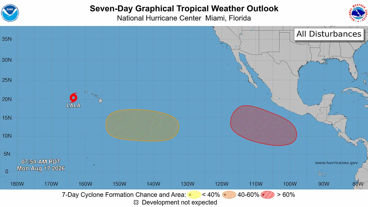
The National Hurricane Center has flagged a broad area of low pressure developing well to the southeast of the Hawaiian chain, with the possibility of a tropical depression forming either late in the week or over the weekend. The center’s daily tropical outlook assigns a 60 percent probability of storm formation within the next seven days — a figure that places the system squarely in the “medium chance” category and warrants close monitoring by island residents and emergency managers alike.
Andy Hazelton, an associate scientist at the University of Miami who tracks Pacific basin dynamics, noted that several numerical models, particularly newer AI-based forecasting tools, are already hinting at a Central Pacific system organizing later this week.
“Right now it’s looking like it’ll hopefully stay southwest of the islands but it’s something to watch for sure.”
Private-sector forecaster AccuWeather confirmed it is tracking the same potential system and scheduled an updated advisory for August 18. For islanders, that means another round of briefings, possible flight disruptions, and the familiar anxiety of watching a dot on a satellite loop drift toward the archipelago.
A Second System Further East: Iselle or Julio Next
Beyond the immediate southeast disturbance, the hurricane center identified a second area of organization even farther to the east in the Eastern Pacific. That system carries an 80 percent chance of developing into a tropical depression over the next seven days — a notably high probability that signals strong large-scale forcing from the El Niño-enhanced warm pool.
If that eastern system earns a name, it will become the season’s ninth named storm. The Atlantic-Pacific naming rotation places Iselle and Julio as the next two designations available. For context, a nine-storm season in the Eastern Pacific is well above the climatological average and underscores just how anomalously active this year’s basin has been, driven by sea-surface temperatures running several degrees above normal.
Lala’s Rainfall Record: Numbers That Rewrite the Books
While forecasters turn their attention eastward, the scale of what Lala already delivered to Hawaii remains staggering. The highest unofficial measurement reported as of Monday morning, August 17, stood at 43.55 inches of rain at the Laupāhoehoe Natural Area Reserve on the northeast coast of the Big Island, according to the National Weather Service in Hawaii. That single gauge reading placed Lala among the wettest tropical cyclones ever recorded in the United States.
The deluge was not confined to one point. A broad swath of the windward coast — the rain-shadow side facing the trade winds — recorded totals exceeding 20 inches, triggering flash floods, landslides, and the closure of major highways across multiple islands. Municipal water systems strained under the volume of runoff, and agricultural operations on the slopes of Mauna Kea and Hualālai faced crop losses from saturated soils.
Michael Lowry, a hurricane specialist with WPLG-TV in Miami, offered perspective on where Lala would land in the historical rankings:
“If the report verified, Lala is likely to go down as ‘one of the top 10 wettest tropical cyclones on record for the U.S. and perhaps the third wettest to affect Hawaii.'”
In the narrow context of Hawaii specifically, Lala would slot in behind two historic monsters: Lane in 2018, which dumped 58 inches, and Hiki in 1950, which delivered 52 inches. Those two events remain the benchmark against which every subsequent Pacific storm is measured, and Lala’s 43.55 inches would close the gap considerably.
Tracking the Wettest: A Database Behind the Headlines
David Roth, a meteorologist with the Weather Prediction Center — the National Weather Service’s national-scale forecasting hub — maintains the authoritative database of the wettest tropical systems to strike the United States and its territories. His records, updated continuously as gauge reports are verified, form the backbone of every “top-10 wettest” list that circulates after a major rain event. As of August 6, before Lala’s deluge, the top-10 ranking stood without Lala’s entry; the storm’s verified totals would now force a reshuffling of that list.
Why El Niño Matters for Island Residents
The El Niño phase of the ocean-atmosphere cycle shifts the warm pool eastward, deepening convection over the Central and Eastern Pacific and weakening the trade winds that normally shear apart developing storms. The result is a basin that produces more storms, faster, with stronger moisture transport. For Hawaii, which sits at the western edge of that active zone, the practical implication is a compressed window of threat: multiple systems can form in quick succession, leaving little time between recovery operations and the next event.
Island residents are advised to monitor the National Hurricane Center’s tropical outlooks daily, keep emergency kits stocked, and know their evacuation routes — particularly those on windward slopes where rainfall totals can exceed 40 inches in a single event. The El Niño signal suggests this pattern of back-to-back threats is not an anomaly but the expected operating mode for the remainder of the season.
Related Reading
Frequently Asked Questions
What is Hurricane forecasters fear more threats brewing?
Hurricane forecasters fear more threats brewing is the main topic of this guide. The article explains the context, practical details, and next steps readers should understand.
Why does Hurricane forecasters fear more threats brewing matter?
Hurricane forecasters fear more threats brewing matters because readers are looking for a useful answer, not just a short summary. Good content should match search intent and help them decide what to do next.