Huge ‘hybrid storm’ will form over the US

Daftar Isi
Hybrid Weather System Raises Flood Concerns Across Central United States
Cybersecarmor.com – A broad stretch of the central United States faces several days of soaking rain and a growing flood threat as tropical moisture combines with a large weather pattern moving east from the West. The developing setup could affect communities from the Southwest through the Plains and into parts of the Midwest through the middle of the week.
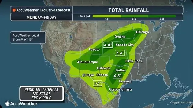
Forecasters expect the remnants of Hurricane Polo to contribute deep tropical moisture to the system. That moisture will interact with an upper-level low, sometimes called a trough, advancing into the central states. The result is expected to be a sprawling hybrid storm capable of producing repeated rounds of rain rather than a brief, isolated event.
“As these features combine into a new, hybrid storm, the influx of moisture spreading across the central United States will pose the risk for flash flooding,” AccuWeather meteorologist Alyssa Glenny said.
Tropical Moisture Meets a Large-Scale Weather Pattern
The National Weather Service expects moisture tied to the remnants of Hurricane Odalys and Hurricane Polo to move from the Southwest toward the central United States. Heavy to excessive rainfall may persist for several days, creating flood impacts that could range from limited in some places to considerable in others.
Flood watches remain in effect through Sept. 30 across portions of the Southwest. Such watches signal that flooding is possible and should prompt residents to monitor local forecasts, alerts, and changing road conditions.
Marc Chenard, a meteorologist with NOAA’s Weather Prediction Center, said the upper-level low will pull additional moisture north from the Gulf. That added supply of humid air is expected to expand the footprint of the heavy-rain event.
“This will produce a widespread area of heavy rainfall.”
Chenard noted that the central United States would still be facing a notable rainfall and flooding risk even without Polo’s remaining moisture. The tropical influence, however, adds to an already favorable environment for persistent downpours.
Texas, Southwest and Plains Could Receive the Heaviest Rain
Rain may extend from Arizona toward Chicago, but the most intense bands are expected to focus on Texas, eastern Arizona, Oklahoma, southwestern Colorado, Kansas, and Nebraska. Some locations within that corridor could receive as much as 8 inches of rain.
Flash flooding is a particular concern because intense rainfall can overwhelm dry washes, drainage channels, small streams, and urban stormwater systems in a short period. The danger is not limited to places where rain falls continuously; a few powerful bursts over vulnerable terrain can quickly create hazardous conditions.
Parts of New Mexico and western Texas could experience considerable flash flooding beginning Sept. 28 and continuing into midweek. Elsewhere in the wider Southwest, burn scars, low-water crossings, and rugged terrain may be especially susceptible to runoff and rapidly rising water.
Burn scars can be risky during heavy rain because vegetation that once slowed runoff may have been removed by fire. Water can move quickly over the ground, carrying mud, rocks, and debris into lower-lying areas. Low-water crossings may also become dangerous with little warning, even when rainfall is falling farther upstream.
A Predecessor Rain Event May Worsen Local Impacts
The pattern may also include what meteorologists call a predecessor rain event, or PRE. This is a zone of heavy rain that can form hundreds of miles ahead of a tropical cyclone when the cyclone’s moisture connects with another weather system. It can lead to serious flooding before the tropical system itself reaches an area.
“A predecessor rain event is shaping up over the Four Corners of the southwest U.S. today (Sept. 28) courtesy of abundant tropical air streaming northward from Polo and the remnants of once Hurricane Odalys to its west,” said WPLG-TV hurricane specialist Michael Lowry in a Substack post.
The Four Corners region, where Arizona, Colorado, New Mexico, and Utah meet, is among the areas where tropical moisture and the broader atmospheric pattern could interact most efficiently. Residents should pay attention to localized warnings because the heaviest rain may not fall evenly across the region.
Ground that has already received substantial rain in recent weeks may be less able to absorb additional water. Saturated soil increases the chance that rain will run off into creeks, streets, and rivers, raising the potential for both flash flooding and longer-lasting river flooding.
Flood Risk Expands Eastward During the Week
By Sept. 29 and Sept. 30, eastern Nebraska and western Iowa could face flash flooding, urban flooding, and river flooding. Central Texas and southern Oklahoma may also see flash, urban, and river flood impacts beginning around the middle of the week.
Urban flooding can develop when rain falls faster than streets, gutters, and drainage infrastructure can handle it. Drivers should not assume a familiar roadway remains safe during a storm, particularly near underpasses, creek crossings, and low-lying intersections.
The National Weather Service advises avoiding travel through flooded or flood-prone areas. Nighttime travel requires extra caution because standing water and washed-out roads can be difficult to see.
“Be especially cautious at night. If you encounter flooding while driving, turn around, don’t drown” the weather service said.
Residents across the threatened region can prepare by keeping weather alerts enabled, checking travel routes before leaving, and avoiding areas where water is moving across roads. Flood conditions can change quickly, especially during repeated thunderstorms, so local warnings should take priority over a general regional forecast.
Related Reading
Frequently Asked Questions
What is Huge hybrid storm will form over?
Huge hybrid storm will form over is the main topic of this guide. The article explains the context, practical details, and next steps readers should understand.
Why does Huge hybrid storm will form over matter?
Huge hybrid storm will form over matters because readers are looking for a useful answer, not just a short summary. Good content should match search intent and help them decide what to do next.