Hurricane forecasters watch ‘unusual’ activity in Atlantic

Daftar Isi
Atlantic Forecasters Track Unusual Storm Development Near Western Europe
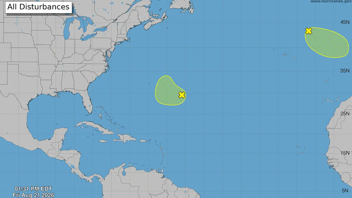
Cybersecarmor.com – For much of the 2026 summer season, tropical storm headlines have belonged to the Pacific basin. Yet the Atlantic has not gone quiet entirely. A low-pressure feature now sitting several hundred miles north-northeast of the Azores is drawing close scrutiny from forecasters because of its extraordinary position — far to the northeast of where most Atlantic storms form, and uncomfortably close to the coastlines of Portugal and northwestern Spain.
The National Hurricane Center confirmed it is monitoring the system, describing it as a non-tropical area of low pressure that has developed over the northeastern Atlantic. The center noted the feature could acquire subtropical or tropical characteristics on Saturday, Aug. 22, or early Sunday, Aug. 23, while tracking east-southeastward at 10 to 15 mph toward the Iberian Peninsula.
“The little low-pressure system west of Portugal is going to put on a show in the coming 24-36 hours,” Weather Trader meteorologist Ryan Maue wrote on X on Aug. 21.
What the System Could Become
If the feature strengthens to tropical-storm intensity, it will receive the fourth name on the Atlantic naming list: Dolly. That would make it only the fourth named storm of the 2026 Atlantic season — a season that has so far produced just three unremarkable storms (Arthur, Bertha, and Cristobal) before any hurricane development.
The scarcity of Atlantic activity this year is largely attributable to two persistent inhibitors: strong wind shear associated with El Niño conditions aloft, and a thick plume of dry, Saharan dust air advecting westward from Africa. Meteorologist Matt Lanza described the combined effect as capable of “obliterating” otherwise developing systems before they can organize.
Why the Location Matters
What sets this event apart from routine Atlantic development is not its potential strength but its geography. The U.K.-based Kernow Weather Team flagged the situation on X, noting the rarity of the NHC highlighting tropical development this far northeast in the basin.
“Seeing the National Hurricane Centre highlighting potential tropical development this far northeast in the Atlantic and relatively close to western Europe is certainly unusual, although it isn’t completely unheard of,” the team wrote.
Portugal and its autonomous Azores archipelago sit at the far eastern edge of the Atlantic basin. While tropical or post-tropical cyclones occasionally brush the Azores, mainland Portugal is affected far less frequently. The National Oceanic and Atmospheric Administration (NOAA) notes that storms surviving far enough east — or transforming into powerful post-tropical cyclones — can deliver heavy rainfall, damaging winds, and coastal flooding to the region.
Historical Precedent: Hurricane Leslie, 2018
The most notable recent example is Hurricane Leslie, which crossed the Atlantic over roughly three weeks before striking mainland Portugal in October 2018 as an extratropical cyclone. At the time of impact, Leslie was the strongest post-tropical cyclone to hit the Iberian Peninsula since 1842, per the hurricane center’s historical record.
“Leslie wandered across the subtropical Atlantic for about 3 weeks before finally hitting Portugal as an extratropical cyclone,” the hurricane center reported.
One fatality was recorded in Portugal — a person killed by a fallen tree — and 27 others were injured. Remnant flooding from the system also claimed at least 10 lives in southern France, the center noted. The event underscored how a system that begins as a modest Atlantic disturbance can, given enough time and favorable steering currents, deliver catastrophic impacts thousands of miles from its genesis region.
NOAA’s Historical Hurricane Tracks database shows that 47 tropical storms and hurricanes have passed within 60 miles of Portugal and the Azores since the 1950s. None exceeded Category 2 intensity. No hurricane has ever made landfall on mainland Portugal.
Other Features Under Watch
The hurricane center is simultaneously tracking a weaker area of low pressure in the central subtropical Atlantic, a few hundred miles east-southeast of Bermuda, producing disorganized showers and thunderstorms as of the afternoon of Aug. 21. Forecasters expect any development from that feature to be slow, with the system drifting west-southwestward through Sunday before turning northward early the following week.
A third area of interest sits along the African coast. Computer models have begun picking up a developing system there, and some model runs project it organizing into the first hurricane of the 2026 season over the central Atlantic within the coming days. If that scenario materializes, it would mark a sharp shift in the basin’s activity after a notably quiet first half of the season.
What Residents Should Monitor
For communities in western Portugal, the Azores, and northwestern Spain, the key question over the next 48 to 72 hours is whether the northeastern Atlantic feature completes its transition to tropical or subtropical status. Even a modest tropical storm at that latitude can produce sustained winds of 39 to 73 mph, gusts well above that threshold, and rainfall totals that stress drainage infrastructure not designed for tropical-scale precipitation. Coastal communities in the Azores, in particular, should watch for elevated surf, rip-current risk, and localized flooding as the system approaches.
Forecasters will issue updated advisories through the weekend. The convergence of an unusually far-eastern development, a historically quiet season, and the lingering influence of El Niño shear makes this event a focal point for Atlantic forecasters and a reminder that the basin’s eastern reaches remain capable of producing weather of consequence.
Related Reading
Frequently Asked Questions
What is Hurricane forecasters watch unusual activity in Atlantic?
Hurricane forecasters watch unusual activity in Atlantic is the main topic of this guide. The article explains the context, practical details, and next steps readers should understand.
Why does Hurricane forecasters watch unusual activity in Atlantic matter?
Hurricane forecasters watch unusual activity in Atlantic matters because readers are looking for a useful answer, not just a short summary. Good content should match search intent and help them decide what to do next.