Hurricane season is broken. Two oceans are historically out of whack

Daftar Isi
Atlantic Calm and Pacific Surge Define an Unusual 2026 Hurricane Season
Cybersecarmor.com – With the Atlantic hurricane season entering its final stretch, the contrast between two major tropical basins has become extraordinary. The Atlantic has remained unusually quiet, while the eastern and central Pacific have produced a rapid succession of storms and hurricanes.
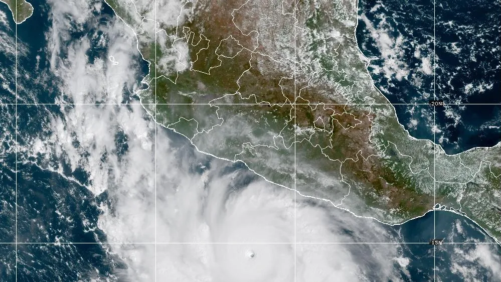
Only seven named tropical storms had formed in the Atlantic by Sept. 25. None had strengthened into a hurricane. Across the Pacific, however, 18 named systems had already developed, including eight hurricanes in the eastern Pacific.
That imbalance stands out because the two basins often finish a season with broadly comparable totals. By the Nov. 30 end of the season, each normally records roughly 14 to 15 named storms and seven to eight hurricanes. In 2026, the Pacific had already reached the usual hurricane range while the Atlantic was still waiting for its first.
Gonzalo Arrives Late in a Hostile Atlantic
Tropical Storm Gonzalo formed in the Atlantic on Sept. 25 as the year’s seventh named system, arriving about three weeks later than the typical timing for a storm assigned the letter G. It moved through the Cape Verde Islands while Tropical Storm Fay remained over the open Atlantic.
Neither storm offered much indication that the basin’s broader pattern was changing. Gonzalo was not expected to become a hurricane, reflecting the unfavorable environment that has repeatedly weakened or disrupted Atlantic systems this season.
Strong upper-level winds have been a central obstacle. Wind shear can pull apart a developing tropical cyclone by separating its thunderstorms from the circulation near the surface. Storms need a relatively organized vertical structure to intensify, and persistent shear makes that far more difficult.
The National Hurricane Center indicated that the central and eastern Pacific could add as many as two more named storms by early October, extending an already active period in that basin.
One Climate Pattern, Different Results
El Niño has influenced conditions on both sides of the Americas, but its effects have not produced matching outcomes. Stacy Stewart, a retired National Hurricane Center hurricane specialist who teaches meteorology at Embry-Riddle Aeronautical University, described the season as being connected in part to the powerful “super El Niño.”
In the Atlantic, El Niño-related wind patterns have helped increase damaging shear. Yet El Niño is not the sole reason for the sparse storm count. Stewart also pointed to dry air, Saharan dust and drought conditions in Ethiopia as factors suppressing the pipeline of disturbances that can eventually become Atlantic tropical cyclones.
The Pacific has presented a very different setting. Once disturbances reached waters west of Central America, some found an environment supportive of development and intensified into major tropical systems. The result has been fierce Pacific hurricanes alongside mostly modest Atlantic storms.
A Long Journey From Africa
Many people living around the Atlantic may not realize that weather patterns over Africa can influence the threats they face months later. Tropical waves often begin over or near the Ethiopian Highlands, cross the Sahara and move westward off Africa’s coast into the Atlantic.
Satellite observations operated by the National Oceanic and Atmospheric Administration allow forecasters and researchers to follow these disturbances from their earliest stages through their movement across oceans. More than six decades after satellites first became an important hurricane-monitoring tool, scientists are still refining their understanding of where tropical waves form and why some survive while others fade.
Dozens of waves leave western Africa in a typical year, but most never become named storms. Kelly Núñez Ocasio, an assistant professor in Texas A&M University’s atmospheric sciences department, has noted that waves tied to the Ethiopian Highlands can be more likely to develop into hurricanes when conditions elsewhere are favorable.
The region’s mountainous terrain can help generate large clusters of thunderstorms. Those clusters may provide stronger initial disturbances, giving a wave a better chance of enduring the difficult passage across the Sahel, through dry air and into the tropical Atlantic.
“Strong enough to survive the trek across the African Sahel region and resist shear”
That process has been weakened this year by drought in Ethiopia, which has limited the thunderstorm activity needed to create some of the larger, more resilient storm clusters. Fewer robust waves reaching the Atlantic means fewer opportunities for a tropical cyclone to organize, even before it encounters hostile winds and dry air over the ocean.
Pacific Hurricanes Can Share African Origins
Not every African tropical wave ends its journey in the Atlantic. Some continue westward across the northern edge of South America, pass over Central America and emerge into the eastern North Pacific. There, warmer water and more favorable atmospheric conditions can allow a disturbance to develop.
Pacific hurricanes Fausto and Genevieve both began as disturbed weather that moved off the hot, dry African continent near Cape Verde. Their westward path carried them across Central America before they reached the eastern Pacific and strengthened into hurricanes.
The routes of Fausto and Genevieve illustrate why hurricane monitoring is not limited to one coastline or one ocean. A wave that fails to organize in the Atlantic can remain identifiable for days or longer, eventually reaching a different basin where the environment is more conducive to cyclone formation.
What the Season Means for Coastal Residents
The subdued Atlantic season should not be confused with an absence of risk. Hurricane season remains open through Nov. 30, and tropical weather can still form later in the year. A quiet basin can produce damaging storms if even one system reaches a populated coastline.
For residents in hurricane-prone areas, the practical lesson is to maintain preparations even when seasonal totals are below normal. Reviewing evacuation plans, checking emergency supplies, monitoring official forecasts and understanding local alerts remain important through the end of the season.
At the same time, 2026 has offered an unusually clear example of how connected the world’s tropical weather systems can be. The same broad climate influence and some of the same African-born waves have contributed to dramatically different stories: a restrained Atlantic and a Pacific season already running far ahead of its usual pace.
Related Reading
Frequently Asked Questions
What is Hurricane season is broken Two oceans?
Hurricane season is broken Two oceans is the main topic of this guide. The article explains the context, practical details, and next steps readers should understand.
Why does Hurricane season is broken Two oceans matter?
Hurricane season is broken Two oceans matters because readers are looking for a useful answer, not just a short summary. Good content should match search intent and help them decide what to do next.