Tropical Storm Bertha forms in the Gulf, forecasts warn of flooding

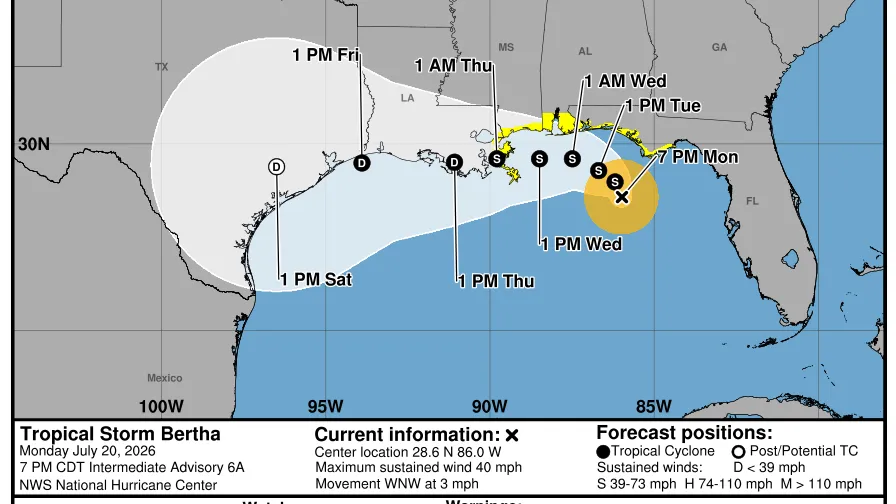
Bertha Takes Shape in Gulf Waters as Coastal Communities Brace for Impact
Cybersecarmor.com – Federal meteorologists issued alerts on the evening of July 20 regarding Tropical Storm Bertha, which remained relatively stationary at that time. The system has the potential to deliver tropical storm-force winds, substantial precipitation, and coastal inundation to sections of the northern Gulf shoreline over the upcoming days.
According to the National Hurricane Center, Bertha represents the second officially named storm of the Atlantic hurricane season for 2026. The cyclone strengthened from a tropical depression earlier on July 20, marking its progression toward tropical storm status.
Current Position and Movement Patterns
As of the hurricane center’s advisory issued at 10 p.m. CDT, Bertha sat approximately 140 miles south of Panama City, Florida, and roughly 215 miles southeast of Mobile, Alabama. The system maintained maximum sustained winds reaching 40 miles per hour at that observation point.
Meteorologists anticipate a gradual west-northwestward or purely westward trajectory for Bertha over the next several days. The storm is projected to track near or directly along the northern Gulf Coast during this period. Some additional intensification remains possible through July 21 as conditions evolve.
Watches and Warnings in Effect
Tropical storm watches have been activated along the Gulf Coast, signaling that strong winds, heavy rainfall, and hazardous surf conditions may develop from late July 20 through July 21. Additionally, a storm surge watch covers the stretch from the Alabama-Florida border extending to the mouth of the Mississippi River.
Authorities and residents across Louisiana and Texas have been urged to closely track Bertha’s development. Forecasters noted that additional watches or warnings could become necessary for parts of that region on July 21 as the situation progresses.
Rainfall Expectations and Flooding Concerns
The hurricane center outlined precipitation projections, stating that Bertha is expected to deliver rainfall totals ranging from 2 to 4 inches, with localized areas potentially receiving up to 8 inches. These amounts are forecast through Friday, affecting the Gulf Coast and nearby inland zones stretching from western Florida to the Middle Texas Coast. Southern portions of Alabama, Mississippi, and Louisiana fall within this affected region. The precipitation may trigger flash flooding, particularly in urban environments where impervious surfaces limit water absorption.
While rainfall will be welcome across portions of the Florida Panhandle due to an ongoing drought, the flooding risk can be increased due to dry soil. This dry, hard soil can allow the water to run off instead of being absorbed right away.
AccuWeather meteorologist Alex DaSilva provided this assessment in an online update regarding the complex relationship between drought conditions and flood potential.
Should the heavy rain shift further westward into the Texas Hill Country, meteorologists at AccuWeather indicated elevated concerns for flash flooding. The region’s terrain, combined with recent significant flooding events, creates conditions where additional precipitation could quickly overwhelm drainage systems.
Season Outlook and Historical Context
Bertha’s formation follows a busy period for Gulf storms, arriving approximately one month after Tropical Storm Arthur developed in the same region. Looking ahead, forecasters project that the 2026 Atlantic hurricane season will experience below-normal activity levels. This reduced activity is primarily attributed to the storm-suppressing influence of El Niño conditions.
The National Oceanic and Atmospheric Administration’s seasonal outlook anticipates between eight and 14 named storms for the current season, with three to six of those systems expected to strengthen into hurricanes. Historical data spanning from 1991 to 2020 reveals that a typical year produces approximately 14 tropical storms, of which seven usually develop into hurricanes.
As Bertha continues its slow journey toward the coast, communities along the northern Gulf are preparing for the possibility of prolonged wet weather and potential flooding. The combination of current rainfall projections and dry soil conditions in certain areas suggests that even moderate precipitation could lead to significant localized impacts.