Videos show scope of devastating Nepal landslide

Daftar Isi
Himalayan Border Landslide Leaves Hundreds Dead as Mud and Ice Devastate Nepal and Tibet
Cybersecarmor.com – A wall of ice, shattered rock, and churning water tore through mountain villages along the Nepal-China frontier on Wednesday, burying entire neighborhoods and severing the lifelines that connect remote Himalayan communities to the outside world. The catastrophe, one of the deadliest natural disasters to strike the region in recent memory, has killed at least 160 people — 157 on the Nepali side and three in China’s Tibet autonomous region — while hundreds more remain unaccounted for beneath layers of debris.
Officials on both sides of the border cautioned that the final toll is unlikely to be the last number reported. Rescue teams face near-impassable terrain as they push toward isolated hamlets, and every passing hour increases the likelihood that more bodies will be recovered from collapsed structures and buried roadways.
What the Footage Reveals
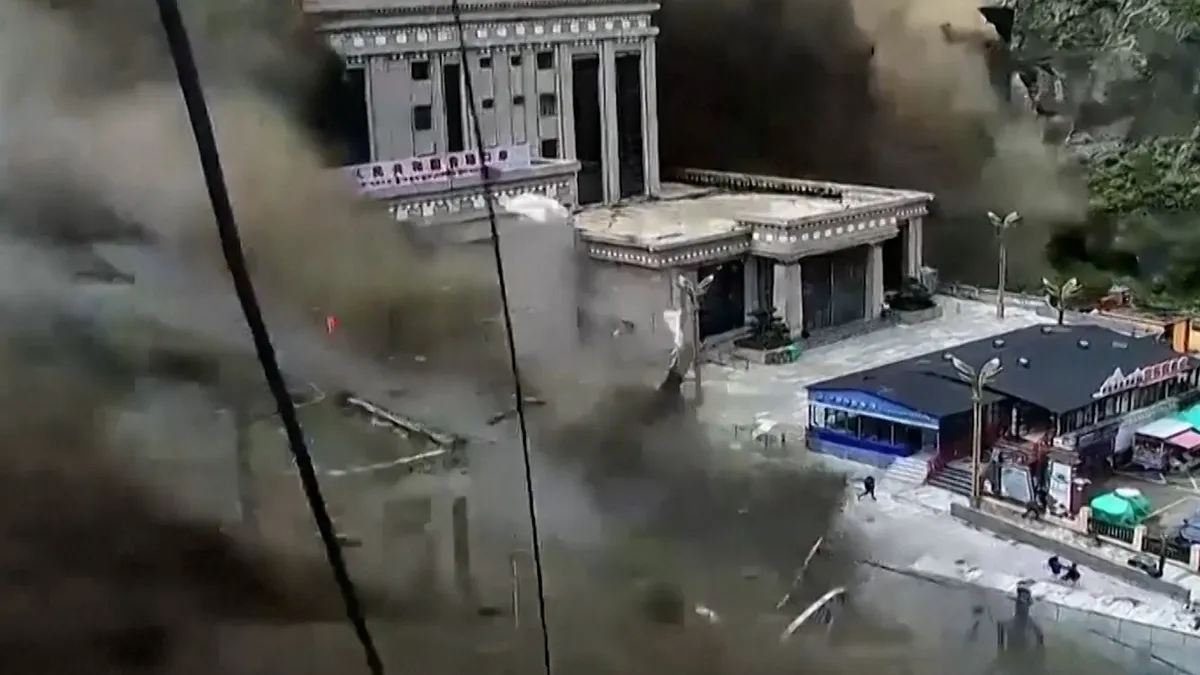
Security cameras positioned at the Chinese end of the Gyirong border crossing recorded the moment the debris wave arrived: a towering front of slurry and boulders surging down the valley floor, sending residents sprinting for higher ground as floodwaters swallowed parked vehicles and swept away sections of the crossing infrastructure. The recordings, captured within seconds of the event, provide an unflinching look at how quickly a mountain stream can transform into a killing machine.
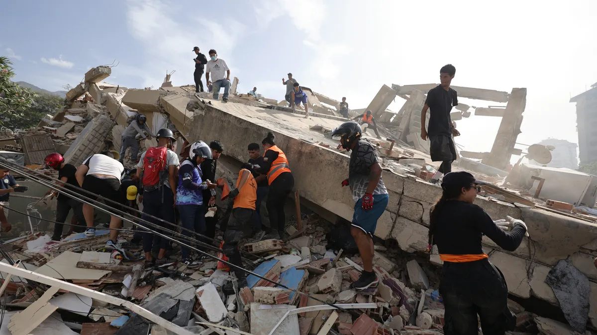
On the Nepali side, the aftermath imagery tells a parallel story. Roads in the Rasuwa district lay buried beneath meters of wet sediment. Homes stood half-submerged, their upper floors barely visible above the mud line. Survivors were carried on stretchers or loaded into helicopters that circled the narrow valleys, searching for anyone still stranded above the flood line. Vehicles sat encased in gray crust, their windshields cracked, their tires buried. Sections of highway simply ceased to exist, replaced by a chaotic jumble of timber, concrete fragments, and raw earth.
Photographs from ground-level rescue operations showed injured residents receiving first aid under makeshift shelters, while others were airlifted to staging areas where medical teams awaited. The visual record underscores a grim logistical reality: in a region where the nearest hospital may be a day’s drive away under normal conditions, helicopter capacity becomes the difference between survival and death.
The Geological Trigger
Nepal’s National Disaster Risk Reduction and Management Authority identified the Lhende River corridor as the epicenter of destruction, where an ice-and-rock collapse generated a debris-laden flood of extraordinary volume. Satellite imagery later confirmed that a segment of a glacier sitting at roughly 17,060 feet above sea level had fractured and plunged into the valley below, hurling ice blocks, fractured bedrock, and accumulated sediment directly into the river channel.
The precise sequence of causation remains under investigation. The German Research Centre for Geosciences noted that a magnitude 4.4 earthquake was registered in the area approximately seven minutes before the security cameras captured the first surge of water. Whether that tremor was the final nudge that destabilized an already-stressed glacier tongue, or merely a coincidental seismic event in a tectonically active zone, has not been determined. Experts emphasized that the question matters for future risk modeling but does not change the immediate humanitarian imperative.
Aerial video provided a wider perspective on the Bhote Koshi River basin, showing floodwaters braiding through multiple communities simultaneously, cutting off access roads and isolating entire wards from supply and evacuation routes.
Impact on China’s Tibet Region
The Gyirong border port — a key node for trade and transit between Kathmandu and Lhasa — bore the brunt of the debris flow on the Chinese side. Local authorities reported three fatalities and 265 missing persons in the Gyirong area. Roads, telecommunications lines, and electrical distribution networks were all damaged or destroyed. China dispatched surveillance drones to map the extent of structural damage and staged fixed-wing aircraft and helicopters for sustained rescue and evacuation operations.
Downstream Alerts in Northern India
The disruption did not stop at the border. Rivers that originate in the high Himalayas and flow southward through Nepal and into India’s Gangetic plain began rising within hours. In Bihar state, authorities issued evacuation orders for thousands of residents living along vulnerable riverbanks. People were moved from six districts, with contingency plans in place to relocate as many as 10,000 to 12,000 additional residents from zones deemed at risk of secondary flooding. The episode highlighted how a single high-altitude collapse can propagate its consequences across three national borders within a matter of hours.
Why This Region Is Increasingly Vulnerable
The Himalayan border zone sits at the collision point of the Indian and Eurasian tectonic plates, making it one of the most seismically active corridors on Earth. Decades of glacial retreat, driven by rising temperatures, have left ice masses structurally weaker and more prone to sudden calving events. When a large ice tongue fails, the resulting outburst flood — sometimes called a glacial lake outburst or, in this case, a direct glacier-avalanche flood — can carry enough momentum to obliterate infrastructure built to withstand ordinary monsoon-season flows. Engineers and disaster planners in South Asia have long warned that the frequency and magnitude of such events will climb as the climate warms, making the Wednesday disaster not an anomaly but a preview of a recurring hazard.
For the families now waiting in staging areas, in hospital corridors, and in temporary shelters scattered across the Rasuwa and Gyirong corridors, the geological explanation offers no comfort. What they need is the slow, methodical work of search-and-rescue teams moving through terrain that no longer resembles the landscape they knew before Wednesday.
Related Reading
Frequently Asked Questions
What is Videos show scope of devastating Nepal?
Videos show scope of devastating Nepal is the main topic of this guide. The article explains the context, practical details, and next steps readers should understand.
Why does Videos show scope of devastating Nepal matter?
Videos show scope of devastating Nepal matters because readers are looking for a useful answer, not just a short summary. Good content should match search intent and help them decide what to do next.