Hurricane center eyes depression that could become Tropical Storm Fay

Daftar Isi
Atlantic Tropical Depression Could Become Fay This Weekend
Cybersecarmor.com – A newly organized tropical depression in the central Atlantic is drifting slowly northward and may strengthen into Tropical Storm Fay later this weekend, adding a potential sixth named system to an unusually quiet 2026 hurricane season.
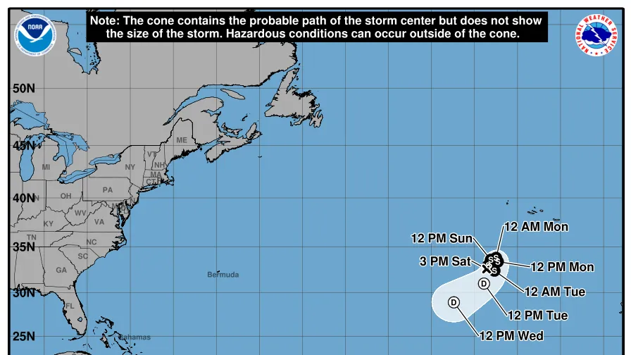
The National Hurricane Center designated the system Tropical Depression Six on Sept. 19. At 11 a.m. ET, its center was positioned roughly 525 miles southwest of the Azores, with sustained winds near 35 mph. The depression was moving north at only about 2 mph, a pace that reflects its sluggish, meandering motion over open water.
For the system to receive a name, its maximum sustained winds would need to reach 39 mph or greater. Forecast conditions may allow some strengthening during the next day, with winds potentially increasing to about 45 mph. If that occurs, the next name on the Atlantic list would be Fay.
Limited Risk to Land
The depression is not expected to produce direct effects on land. Its location far from major populated coastlines is an important part of the forecast, even as meteorologists continue to monitor its evolving path and strength.
After a short opportunity for intensification, the system is expected to weaken gradually after roughly 36 hours. It could dissipate within several days as environmental conditions become less supportive of an organized tropical cyclone.
This depression may strengthen into a tropical storm and slowly move northeastward before changing direction to the southwest and heading away from the Azores into early next week,
AccuWeather Meteorologist Alexander Duffus said the expected track would initially take the system toward the northeast before a turn back toward the southwest, carrying it farther away from the Azores.
Why the Storm’s Classification Matters
Tropical depressions are organized areas of low pressure with rotating thunderstorms and sustained winds below tropical-storm strength. Once sustained winds reach at least 39 mph, the system is classified as a tropical storm and receives an official name.
That naming process helps residents, mariners and weather agencies distinguish one active system from another during the hurricane season. In this case, the immediate concern is not a landfall threat, but the possibility that the depression could briefly cross the tropical-storm threshold while remaining over the Atlantic.
The Azores, a Portuguese archipelago in the North Atlantic, are the nearest major land area to the system. Current expectations place the depression well southwest of the islands, and the projected shift away from them would further reduce concerns for direct impacts.
A Historically Slow Atlantic Season
If the depression becomes Fay, it would break a notable quiet stretch following Tropical Storm Edouard, which made landfall in Louisiana in early September. The Atlantic basin has experienced a historically slow start to the 2026 season, including the longest period on record without a hurricane at this point in the calendar year.
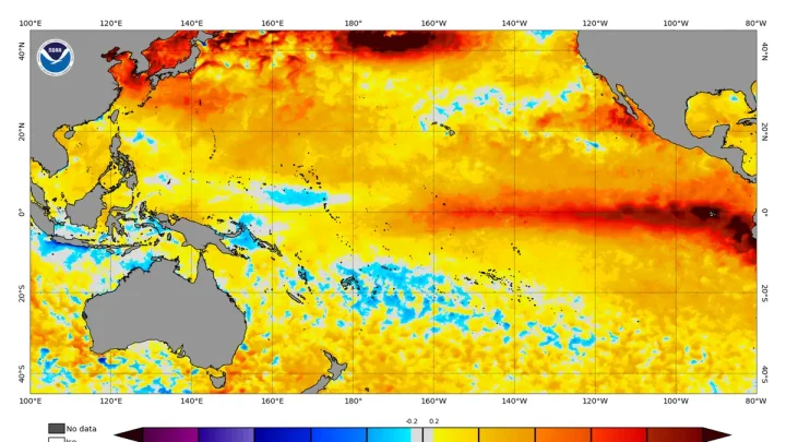
El Niño has played a role in limiting storm development and organization. The climate pattern can create atmospheric conditions that make it harder for tropical systems to form or strengthen, helping suppress activity in parts of the Atlantic basin.
Even with a possible Tropical Storm Fay, the season would remain behind its usual pace. Fay would be the sixth named Atlantic storm of 2026, arriving weeks later than the historical average date for a sixth named storm. Based on 1991 through 2020 data, that average falls on Aug. 29.
Seasonal averages provide useful context, but they do not determine how many storms will ultimately form or where they may travel. Tropical activity can change quickly as ocean temperatures, wind patterns and atmospheric conditions shift through the remainder of the season.
What to Watch in the Days Ahead
The key forecast question is whether Tropical Depression Six can sustain enough organized thunderstorms and stronger winds to become a named tropical storm. Its anticipated peak winds of 45 mph would place it modestly above the tropical-storm threshold, though strengthening is expected to be limited and short-lived.
Forecasters will also watch its slow motion and eventual change in direction. Slowly moving tropical systems can be difficult to predict precisely, but this depression is expected to remain over water and weaken rather than develop into a more significant threat.
For people in coastal regions, the system is a reminder that the Atlantic hurricane season can remain active even during a slow year. The current depression does not call for direct land preparations, yet monitoring official tropical outlooks remains important as conditions can evolve during the season.
For now, Tropical Depression Six is primarily a maritime weather system in the open Atlantic. Its likely path away from the Azores and its expected weakening suggest limited consequences beyond the possibility of briefly becoming Tropical Storm Fay.
Related Reading
Frequently Asked Questions
What is Hurricane center eyes depression that could?
Hurricane center eyes depression that could is the main topic of this guide. The article explains the context, practical details, and next steps readers should understand.
Why does Hurricane center eyes depression that could matter?
Hurricane center eyes depression that could matters because readers are looking for a useful answer, not just a short summary. Good content should match search intent and help them decide what to do next.